Monday, 7/26/21 Team 60s video summary

I said my goodbye to my sis and Bro-in-law after a one day family reunion, which for those at my old employment, was like the “One Day Ride” – so it was three days of food and company. It was fun.

I got on the road heading to Muskegon MI to catch a 4:30 ferry across the lake to Milwaukee WI with an eye to hook back up with Rick who was meandering around Lake Michigan.

The morning was crisp and clear and dryer than normal after typical humid Michigan summer days.!I stopped by the H-D dealership in Muskegon to pick up some soft ties for the bike and then in line for the ferry.

The ferry was amazingly fast going about 38 knots and steady. Lake Michigan was much bigger than I thought it was and 2 1/2 hrs latter was were in Milwaukee.

We unsecured our bikes and disembarked and an hour later I was having dinner with Rick in Lake Geneva!

7/26/21 Video Summary Team 60s

Posted in Uncategorized | 6 Comments

Monday, 7/26 – 1/2 60s Team heading west again…

After visiting my sisters, friends, lost cousins, visiting stomping grounds and the end of the family reunion /birthday party weekend… it’s time to head west again. Ricks been on the road since Wednesday checking out Lake Michigan coastline.

Posted in Uncategorized | 10 Comments

Thur, 7/22/22, Rt66, Team70s, Day6

Motel Home to Santa Monica Pier – 56 miles

We depart Motel Home around 5:15AM.  Its 53 miles via I-405 to the intersection of Olympic Blvd & Lincoln Blvd.  The early morning traffic into Los Angeles is heavy!  It started backing up near Gardena.

Gary next to the “END of Historic Route 66” sign on the south west corner of Lincoln Blvd and Olympic Blvd.  The Western Terminus of Route 66 from 1936 to 1964 was located on the intersection of Lincoln Blvd. with Olympic Blvd.

Across the street is Mel’s Drive-In.  This location was the former Penguin Coffee Shop, 1959.  It then became the Western Dental & Orthodontics retaining the Penguin atop the sign.  Recently, Mel’s Drive-In has taken over the building and again the Penguin sits atop the sign.  Mel’s Drive-In has claimed ownership of End of the Road.

Gary’s very thankful that the Historic Route 66 Tour is OVER! He immediately heads north back home. He’ll spend the night somewhere past Redding, CA.


It was a wonderful “brother experience” to share! As we found out in our old age we have similar likes and dislikes.

I climbed the BEGIN sign in Chicago. Gary climbs the “End of the Trail” sign on the pier.

Historic Route 66 … DONE!  Completed at 7:37 AM


Posted in Uncategorized | 5 Comments

Thursday 7/22 Team 1/2 60 reminiscing tour – EMU

I’ve been taking care of my Michigan bike (a DL1000 Vstrom) making sure it is running. After changing the regulator on it I decided to take it for a spin to my college stomping grounds- Eastern Michigan University in Ypsilanti MI. Aka the “Gateway to University of Michigan” as we use to say when I was going there. EMU is just about 8 miles from U of M.

Phelps Hall, first time away from home and rules..

The campus at EMU looked similar to what it was 45 years ago, with a few new buildings around. The dorm I first moved into was still there. Phelps Hall that was all guys, across the courtyard was the gals. Did administrators think that the courtyard between the sexes helped with anything?

The Towers

My second year I lived in the top floor of the Towers, which was the only co-ed floor on campus at the time. All the other floors alternated between the sexes.

Typical buildings on campus

I lived on campus two years, off campus the last three and lived in Ypsilanti full time since my dad sold the house I grew up in during my sophomore year. Besides earning my degree in Business Administration with a major in accounting I also learned how to drink and party during those years and still keep in touch with old friends and roommates. It was also a time to learn how to stand on my own two feet!

Iconic water tower in Ypsilanti
The tower was located right off campus

The most notable part of campus was just off campus, the Ypsilanti water tower. This obvious phallic symbol spawned local folklore that to save the tower from falling, no virgin was to graduate from EMU. This spawned t-shirts during my tenure with “Save the Tower” or “Tower Power” printed on them. It is amazing what you remember from college. I went to the campus book store trying to find another t-shirt and couldn’t find any “Save the Tower” shirts, apparently the school wants to clean up its image.

History of the tower
Posted in Uncategorized | 4 Comments

Wed, 7/21/22, Rt66, Team70s, Day5

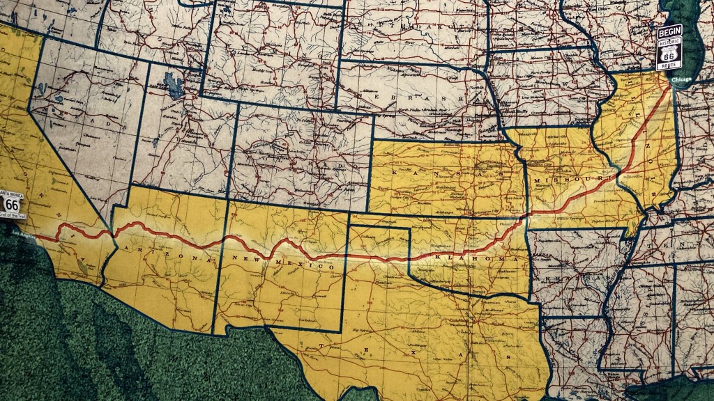
Seligman AZ to Motel Home, Orange County, CA – XXX miles

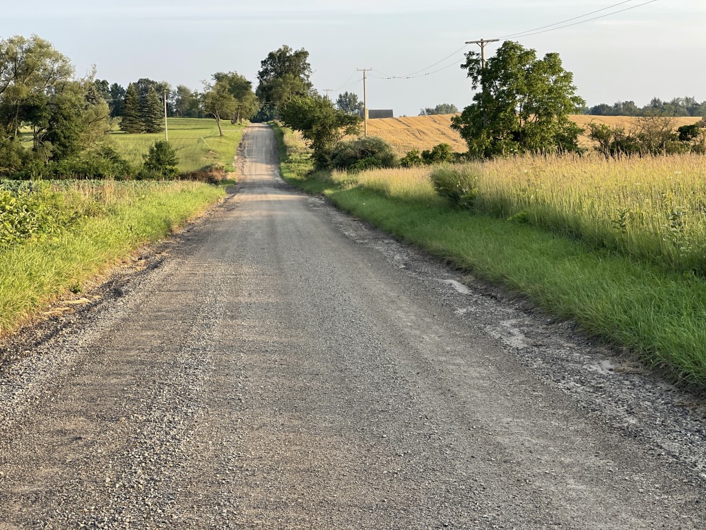
We depart Seligman a little after sunrise.  We elect to stay on Historic Route 66 for 85 miles to Kingman AZ.  It was lonely with little traffic through various Indian reservations and vast expansions of open fields.

We get on I-40 at Kingman and ride 15 miles to the Oatman exit.  The first is Sitgreaves Pass, a twisty mountain road through rugged desert elevations, hair pin turns and sometimes steep corners.  Great riding!  Not sure what the 30’s, 40’s and 50’s travelers thought when they got to Sitgreaves Pass!

Oatman, AZ – A real ghost town!

In 35 minutes from the I-40 we arrive at Oatman!  This village has somewhat of a cartoonish look now with all the Historic Route 66 gimmick Wild West theme.  We saw a lonely burro near the end of Sitgreaves Pass and none in town!  Well, it was 8:45 AM in the morning and we were the only moving humanoids in Oatman!

Oatman was a favorite place to ride to during the Laughlin River Run 20 years ago. There would be 5-6 hundred motorcycles lining the street. Each bar was packed!

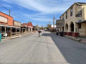
But today at 8:45AM the streets were empty! Not a human or burro in sight!

We cross into California when we cross the Colorado River.  Historic Route 66 crosses I-40 many time here.  It’s like a snake path and I-40 cuts through the center.

Roy’s Motel, Garage & Cafe, Amboy, CA

We’re looking for the turn off to Amboy.  I miss the turn and Gary finds Kelbaker Rd. on his GPS.  When we intersect Historic Route 66/National Trails Hwy a mile east of Amboy, the road east is barricaded!  If we made the earlier turn we would had to turn around at some point and rerouted the way we came!

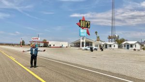
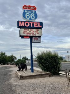
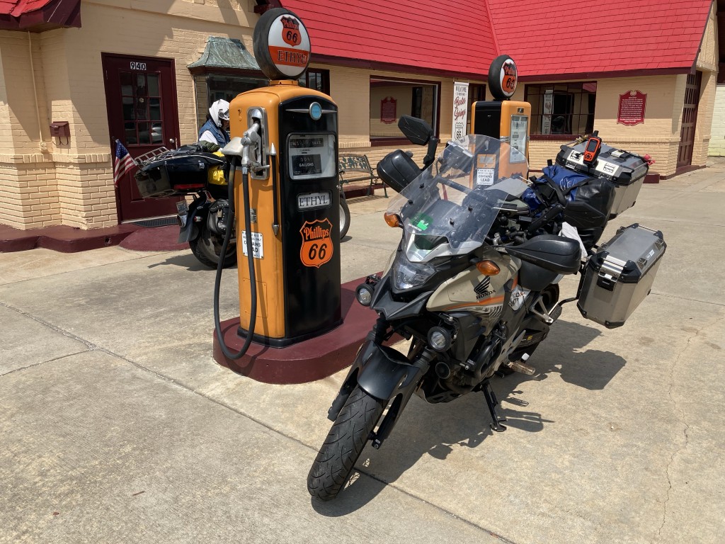
The reason to go to Amboy is Roy’s Motel Cafe. The sign is good but the motel & cafe are not in operation.

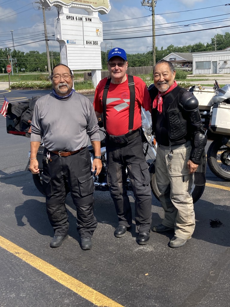
Amboy was the second hottest area we’ve experienced!  112℉ in the shade!  We both hydrate while riding and are constantly reminding each other through out the day to hydrate.  After walking a 150 yards to do our photos, we move our moto’s under the shade of the gas station, souvenir, snacks & drinks shop.  We must have looked pretty haggard when we walked in and shuffled to the cold drink refrigerator.  I grab 2 Gatorades and put them on the counter.  Gary was talking to a regular sitting in a chair who was asking about our ride.  When the owner learned we did the USA Four Corners AND are completing Historic Route 55 he said, “No charge!” for our Gatorades.

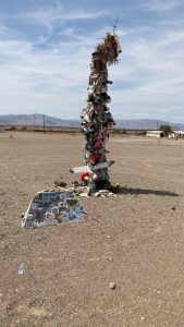
Not sure what this is but there’s suppose to be a shoe tree or bra tree somewhere in Amboy!  We found this but …

Bagdad Cafe, Newberry Springs, CA

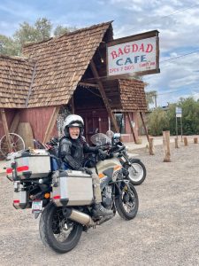
Site of the film “Bagdad Cafe”, the cafe continues serving buffalo burgers and Route 66 souvenirs.

Route 66 Mother Road Museum, Barstow, CA

It’s still hot!

The Harvey House was a huge railroad hotel. The Harvey House Girls were world famous.  They were pretty, young, & intelligent waitresses.  The museum was closed!

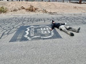
Hydration, Hydration, Hydration! This logo was outside the Harvey House Museum.  Goofing off, I laid down on the asphalt to take this picture.  Probably could have cooked eggs!

Summit Inn & the Cajon Pass

We’re in my back yard.  On the bottom of the Cajon Pass was one of my favorite hang gliding sites!  I’m quite familiar with all the ranges around San Bernardino.

The Summit Inn at the top of Cajon Pass burned down a couple years ago.  The Cajon Pass, a modern 4-lane freeway pass is packed!  Welcome to SoCal!  We head west on I-15 to the 210 W to the 57 S.  Instead of going to get the “Historic Route 66 END” sign late in the day, with commuter bumper-to-bumper traffic, we elect to go to Motel Home in Orange County.

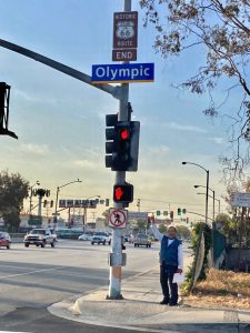
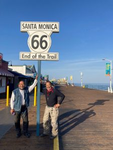
Tomorrow we’ll leave at sunrise and ride 55 miles to the Santa Monica Pier area.  There are three END of Route 66 signs.

1st and original is in downtown Los Angeles.  (We ignore that one)

2nd is the corner of Olympic Blvd & Lincoln Blvd. (Our first choice)

3rd is the feel good, Santa Monica pier token tourist sign (We’ll do this last!)

Posted in Uncategorized | 10 Comments

Sat/Sun/Mon/Tue Team 60’s Video Summary

Well this trick really does work…

Team 60’s was meandering around the northeast since we finished the 4 Corners Tour early. I have a family event on Saturday 7/24 at JanieV’s place to attend, and it looks like we would get to her place earlier. So before we left Mansfield PA we happen to call the local dealer in Manchester MI and found out if service department opened on Monday and due to a shipping of parts on a bike they were working on, they could squeeze our service in on Monday. So the decision was to get to my sisters house on Sunday evening. Two days to do about 500 to 600 miles.. easy !

When we woke up in Mansfield on Saturday morning and checked the weather, there was no way we’re were not going to get rain today. Our goal was to get south of Cleveland.

For this motorcycle trip I’ve been using my old iPhone that hangs around my neck to take pictures while riding. I use my new phone to record the ride and that phone is protected from the elements.

We have run into rain before in this trip but on this particular leg from Mansfield PA to Ohio it was more intense and longer in spots. On our evening and overnight in Ohio I could not get my old iPhones Bluetooth to turn on or WiFi, even after hard resets. I couldn’t even adjust the settings and the camera lens was all foggy. It obviously got some water today, so I couldn’t do any video summary as I had no way to get my pictures from the old phone to the new phone to add to the video.

On Sunday, the weather for our leg from Ohio to Michigan was clear and sunny. We continue to stay off the interstates, but due to the heavy rains, some of the bridges on these smaller farm roads were closed due to flooding.

Once we made it to my sisters, we did the rice in a bag with the phone trick. That evening I noticed that I could turn on bluetooth and Wi-Fi, but the camera was still blurry and foggy. By the end of the next day, the old phone was back to 100%!

So over the last few days team 60’s has been enjoying home cook meals, taking care of our bikes, a pool in the back yard, and I’ve been visiting my old hood where I grew up and went to school. Rick and I also went to visit Axzl and see his improvements at his new home and then we treated him to dinner at a lakefront dinner place.

As typical in summer afternoons in the Midwest, while we were wrapping up dinner out on the patio, we noticed the clouds building and there was a severe thunderstorm warning for the area. The manager came out telling every one on the patio you have three minutes before it starts raining. He overheard us say we won’t make it home in time on our bikes and that we would wait it out. He pointed to a tent and said we could park there and that we would have to wait out 48 minutes, which we did and proceeded to the bar to wait it out.

The scary part was, it did rain in three minutes and it was over in 48 minutes….

After the storm we road back to Axzl’s house, said out goodbyes, and headed back to JanieVs about an hour and 15 minutes away. We missed anymore rain on the way back, but there was plenty of lighting to watch as the storm moved to the east. It was dark when we exited the freeway and we road slowly down the country roads as the fog and steam from the storm was starting to form and lift off the pavement as we did our last 15 miles to the house while watching the fire flies dance all around us.

On Wednesday, Rick wanted to explore some parts of Michigan so he took off to ride the west coast of Lake Michigan with eying the Mackinaw bridge crossing and a ride across the upper peninsula. Rick and I may hook up again on the trip back west, with maybe an eye on Sturgis, but we are keeping the plans loose.

Rick ready to ride

I’m staying at my sister house for the party on Saturday to see a cousin I haven’t known since I was about 4 or 5. I’ll probably leave Michigan on Monday

Video summary for several days

Posted in Uncategorized | 6 Comments

Tue, 7/20/22, Rt66, Team70s, Day4

Albuquerque NM to Seligman AZ – 425 miles

We rode out of Albuquerque with our first stop the El Rancho Hotel, Gallup, New Mexico!

This Hotel was a Hollywood favorite!  The upstairs balcony area had hundreds of photos of    films, and stars of the 30’s, 40’s, 50’s.

Continental Divide, I-40, NM

Of course being guys we wanted to pee on each side of the sign and one’s pee would go to the Pacific and the other side would go to the Atlantic!  But being mature adults, we refrained!

Petrified Forest National Park, I-40, exit 285, AZ

The last time Gary and I were here, Gary was 10 and I was 13!

Wigwam Motel, Holbrook, AZ

The room were around $135 and very basic.  

Standing on the corner, Winslow, AZ

“Well, I’m a-standin’ on a corner in Winslow, Arizona and such a fine sight to see. It’s a girl, my Lord, in a flatbed Ford slowin’ down to take a look at me.”

Meteor crater, I-40, exit 233

Dean is walking out to the observation deck in light but windy rain. Amazing history and used by the astronauts for moon training.

Twin Arrows, Off I-40, Exit 219

The only thing left of a truck stop and cafe are the two huge arrows sticking in the ground!  We were heading to the Twin Arrows, but a mile out we ran into a heavy down pour with lightning and thunder!  We got off at the Twin Arrows exit but ran to the gas station and waited the down pour out … 15-20 minutes.  We could see a second storm approaching and decided to run out ahead of it.  So we missed the Twin Arrows!

Historic Route 66 Motel, Seligman, AZ

This was an old building but fix up with new bathroom fixtures.  The decor was totally Route 66!  Everything seemed to work and we were comfortable!

Posted in Uncategorized | 2 Comments

Mon, 7/19/2021, Rt66, Team70s, Day3

Oklahoma City OK to Albuquerque NM – 554 miles

Team 70s past 3 days have had incredible weather. The days start overcast with low clouds. By 11AM the sun burns through to blue skies with high white clouds.

Each day has become warmer. Today in Albuquerque at 5PM it was 90°F.

Oklahoma Route 66 Museum, Clinton, OK. This was a wonderful museum that details the various periods Route 66 has undergone from concept, construction, depression, war, post war to the interstate highway growth to finally the abandonment of Route 66.
Gary at main entrance.
From Chicago to California! Eight states total.
Leaning Tower of Texas, Groom TX

Missed the Cadillac Ranch! We were 50 miles past the Cadillac Ranch when we realized we blew by it!

Midpoint Cafe, Adrian TX. Claimed to be at the halfway point between Chicago and California! The Historic Route 66 Highway had a huge white line with a sign claiming it was 1,139 miles west to California AND 1,139 miles East to Chicago!! The Midway Cafe was closed today!

Dean and his moto on the Midpoint.
Blue Hole, Santa Rosa, New Mexico
There were a dozen swimmers enjoying the Blue Hole

We ended the day in Albuquerque, NM. We rode 554 miles today.

Posted in Uncategorized | 5 Comments

Sun, 7/18/2021-Rt66, Team70s, Day2

Sullivan MO To Oklahoma City OK – 447 miles

We were on the road around 8 AM. Our first stop was the Devils Elbow. Historical Route 66 was a four-lane cement road through hooker cut, which was once the deepest road cuts in the United States at its time. An offshoot through a tree shaded section to an old iron bridge.

Gary riding up to historic bridge.
The community of Devil’s Elbow
Joplin MO – Bonnie and Clyde lived here above the garage.
Ronnie, Gary & Dee

We stopped to visit Ronny & Dee Baptista in Baxter Springs KS. Ronny is Gary’s wife’s (Kitty) uncle. The Historic Route 66 runs through Baxter Springs! We had a wonderful enchilada lunch!

Unfortunately the Baxter Springs Missouri Route 66 museum was closed! The decour was an old gas station with period fuel pumps, one ethyl and one regular!

From Baxter Springs we rode to Oklahoma City, found a cheap motel, and had steaks for dinner!

Posted in Uncategorized | 3 Comments

Sat, 7/17/2021-Rt66, Team70s, Day1

Into the throat of the beast … Chicago!

Every time I rode a motorcycle near Chicago the traffic has been catastrophically horrendous. It’s miles of bumper to bumper, stop and go traffic!

Our plan is to go into Chicago before daybreak and to be at the Route 66 sign at sunrise.

Our hotel in Merrillville Indiana was 45 minutes from the Route 66 start sign in downtown Chicago. Yesterday’s short day to Merrillville enable us to do this on a Saturday morning.

We woke up Saturday morning at 3:30 AM, we were on the road by 4:30 AM, and we were at the sign by 5:30 AM. Traffic was light all the way in. When we got to the Route 66 sign there was no traffic at all. I parked my bike on the street, Gary pulled up on the sidewalk next to the sign. We took pictures and for 15 minutes we owned the beginning of Adams Street in downtown Chicago!!!

Dean at the “Begin Historical Route 66” sign.
Second sign 25 yards down the street.
Gary pointing Route 66 Begin sign
Michigan Ave & Adams St is the intersection where the Route 66 BEGIN signs are.
Blues Brother’s police car rig at a gas station outside of Chicago. We were kinda lost at this point!

We took Adams Street out of Chicago. Our first goal was to Joliet Prison where Albert met Jake when he got out of prison. One of the many reasons why Chicago traffic is so bad is the massive road construction. It seems all of Chicago’s roads are lines of orange traffic cones that merge to a single lane!

The problem was there were so many detours that every time we ended the detour we were 10 miles further from the prison! After being lost for 30 minutes we gave up and rerouted to Pontiac, Illinois. We had a friend awaiting us 10 miles north of Pontiac.

Rick Martin, IBR finisher, lives in Pontiac MI. He gave us the Pontiac grand tour and hospitality!

Ol’ Iron Butt Rally rider Rick Martin lives in Pontiac IL. He was riding his ol‘ rally ready FJR1200. He was waiting on an overpass as we came chugging by.

Rick gave us the Route 66 tour of Pontiac. The remains of Route 66 parallels the interstate for many miles here. Different towns use it for bike paths, picnic areas, parks, walkways and always title “Historic Route 66.”

Rick took us to breakfast, to the town’s museum, showed us the different generation routes through town and to Wallys World, the building shaped like a derringer (abandoned) before letting us go 30 miles south of Pontiac.

We parked in front of the largest Route 66 sign designed for vehicles and fans to take photos! Rick and Gary are in the background. Great 3- story museum here!
Wally World is basically a huge gas station and souvenir, snack shop.
This is Historical Route 66 outside of Pontiac. It’s at the Derringer shaped building.
The concrete in front of our parked motos is Historic Route 66. Gary is next to an iron silhouette of a motorcycle cop first used to patrol Route 66. It’s at the abandoned derringer building.
Gary in front of Lincoln’s tomb.
Lincoln’s Tomb in Springfield. Lincoln’s nose is shiny because it’s good luck to touch it. Gary went for Lincoln’s ear!
Inside Lincoln’s tomb. This is the original miniature of Lincoln’s Memorial in Washington DC. It’s apparently 18” high.

Our next goal … the St Lous Arch!

The arch is very easy to find! You can see it miles away! However, one again massive construction around the arch! We rode all around but the closest parking was ½-mile away! That walk for Team70s in moto gear and boots in the hot, warm day was the deal breaker … we rode on.

We ended the day at Motel 6, Sullivan, MO. Another 400 mile day!

Posted in Uncategorized | 9 Comments